


Best long cycling routes in Spain
There are hundreds of possible routes to cycle in Spain, but in this article, we focus on 5 of the most iconic, including 3 routes of the Camino de Santiago.
These routes are to be done in several days, which entails a previous preparation, but that does not mean you have to finish them all at once. You always have the option of doing sections and completing the route when you can, while deciding how many kilometres you want to do per day.
Here are 5 cycling routes in Spain. Each one has a different level and most of them offer the possibility of lengthening or shortening the stages depending on your fitness level.
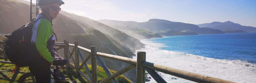
Camino del Norte, The Northern Way
Perhaps the most entertaining and beautiful Camino of all, combining both coast and inland, rural areas and some important cities such as San Sebastian, Bilbao, Santander, Oviedo and, of course, Santiago. The first two thirds of the route are practically coastal, cycling parallel to the sea in the Basque Country, Cantabria and Asturias, going up and down cliffs between different fishing villages. When we reach Ribadeo, on the border with Galicia, we leave the sea behind us and head, almost in a straight line, to Santiago. Here, although we are crossing the interior of Galicia, the ascents are gentler.
Like any Camino, the main route is designed to be done on foot, so it is necessary to prepare the route in advance to avoid sections where you cannot cycle. The solution is usually to follow local roads and thus avoid trails where you would have to carry your bike by hand. But do not be disappointed, as the route is still beautiful and more enjoyable by bike.
Stages and difficulties
As we have mentioned, it is not an easy Camino, especially the coastal part. But cycling it is much easier to adapt the stages to the level of each person, as each cycling stage can be equivalent to 2, 3 or 4 walking stages. Some people propose to do the Camino del Norte by bike in 14 stages, others in 20.
Here below is an average option of 16 stages, and remember that there is always the option of doing it with a regular bike, or with an electric bike:
- Stage 1: From Bilbao to Castro Urdiales (25 miles/41km, 750 m ascent)
- Stage 2: From Castro Urdiales to Laredo (33 miles/33km, 825 m ascent)
- Stage 3: From Laredo to Santander (35 miles/56km, 850 m ascent)
- Stage 4: From Santander to Santillana (29 miles/47km, 725 m ascent)
- Stage 5: From Santillana to Colombres (31 miles/50km, 960 m ascent)
- Stage 6: From Colombres to Ribadesella (33 miles/53km, 1030 m ascent)
- Stage 7: From Ribadesella to Villaviciosa (12 miles/19km, 1200 m ascent)
- Stage 8: From Villaviciosa to Oviedo (27 miles/43km, 900 m ascent)
- Stage 9: From Oviedo to Avilés (19 miles/30km, 400 m ascent)
- Stage 10: From Avilés to Cudillero (20 miles/32km, 575 m ascent)
- Stage 11: From Cudillero to Luarca (34 miles/55km, 680 m ascent)
- Stage 12: From Luarca to Ribadeo (34 miles/55km, 325 m ascent)
- Stage 13: From Ribadeo to Mondoñedo (24 miles/38km, 975 m ascent)
- Stage 14: From Mondoñedo to Vilalba (21 miles/33km, 600 m ascent)
- Stage 15: From Vilalba to Sobrado dos Monxes (32 miles/52km, 635 m ascent)
- Stage 16: From Sobrado dos Monxes to Santiago de Compostela (35 miles/56km, 625 m ascent)
Best time to do the Camino del Norte by bike
Northern Spain is enjoyed from spring to autumn, from March to the end of October. Although temperatures have risen in the summer in recent years and it can now be said to be hot, you will always have a beach nearby to cool off.
If you are planning to stay in hostels or hotels, you will have to adjust to these months, as hostels and hotels outside the cities close for the winter months.
You will need to be prepared for rain and avoid getting your clothes or luggage wet.
Camino Primitivo, The Primitive Way
This is undoubtedly the most demanding Camino where you will have to overcome a couple of mountain passes, so the climbs give no respite, up to 625m to climb the Puerto del Palo (1,146m).
Many pilgrims choose this Camino because it is not so ‘hackneyed’ and is more authentic, without overcrowding. And although it may seem that there are fewer services and accommodation available to cross many rural areas of central Asturias and Galicia, the reality is quite the opposite. In recent years work has been done on the Camino Primitivo and it is well prepared. Other reasons for choosing this route are the physical challenge it represents and the fact that it is a route full of nature.
Stages and difficulties
Although, as we have just mentioned, there is accommodation along the route, the stages are less flexible if your idea is to sleep in hostels, small hotels or rural houses. However, doing the Camino by bike gives flexibility to ride a few kilometres more to reach accommodation.
If you have a limit of kilometres/miles per day due to a physical condition, for example, we recommend planning ahead to ensure you have somewhere to sleep.
Below are two options of stages, one to do it in 6, and the other in 8:
El Camino Primitivo in 6 stages:
- Stage 1: From Oviedo to Salas (48km / 30 mi)
- Stage 2: From Salas to Pola de Allande (58 - 39km / 36 - 24 mi)
- Stage 3: From Pola de Allande to Fonsagrada (67 - 71km / 42 - 44 mi)
- Stage 4: From Fonsagrada to Lugo (54 - 60km / 33,5 - 37,5 mi)
- Stage 5: From Lugo to Melide (46 - 58km / 28,5 - 36 mi )
- Stage 6: From Melide to Santiago de Compostela (54km / 33,5 mi)
El Camino Primitivo in 9 stages:
- Stage 1: From Oviedo to Grado (25km / 16 mi)
- Stage 2: From Grado to Tineo (45km / 28 mi)
- Stage 3: From Tineo to Pola de Allande (28 - 32km / 17,5 - 20 mi)
- Stage 4: From Pola de Allande to Grandas de Salime (39km / 24 mi)
- Stage 5: From Grandas de Salime to Fonsagrada (32km / 20 mi)
- Stage 6: From Fonsagrada to Lugo (60km / 37 mi)
- Stage 7: From Lugo to Palas de Rei (43km / 27 mi)
- Stage 8: From Palas de Rei to Arzúa (29km / 18 mi)
- Stage 9: From Arzúa to Santiago de Compostela (40km / 25 mi)
Best time to do the Primitive Way
The best time to do the Primitive Way is from April to October. As it passes through high areas, you have to wait until April or, depending on the year, until May to avoid encountering some snow.
And although we have mentioned that it is one of the least crowded Caminos, in Melide you will join the pilgrims who come along the route of the French Way, so ‘the tranquillity’ is over, and you will share the experience of reaching Santiago in company. If you are staying in hostels or hotels, book in advance on this last stretch.
.png)
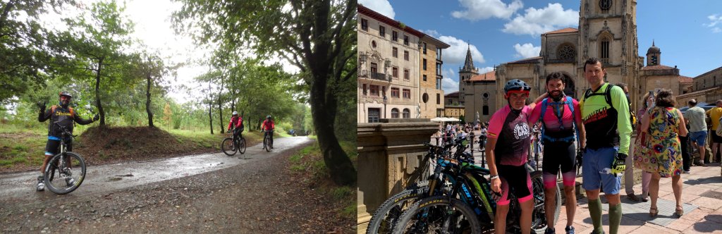
Camino Francés, The French Way
750 km from Roncesvalles to Santiago de Compostela. It is undoubtedly the most popular route and the perfect plan to get started in cycle touring because of all the infrastructure it offers. Besides, as it crosses a large part of the peninsula, the scenic and cultural richness is enormous.
Being so popular, the route is also very well defined for pilgrims who go by bike and thus avoid carrying the bike by the hand in some sections, or share the route with people who go on foot, which can be inconvenient for both parties.
Stages and difficulties
Although there are a couple of somewhat demanding stretches, it is generally an easy Camino. And because there are so many accommodations and albergues available, you can lengthen and shorten the stages very easily.
Below is one of the easiest options, with 14 stages, so that you can get an idea of the possible kilometres and climbs and adjust it to your level:
- Stage 1: From Roncesvalles to Pamplona (27 miles/44km, 609 m ascent)
- Stage 2: From Pamplona to Estella (28 miles/45km, 857 m ascent)
- Stage 3: From Estella to Logroño (30 miles/49km, 809 m ascent)
- Stage 4: From Logroño to Sto. Domingo de la Calzada (31 miles/50km, 746 m ascent)
- Stage 5: From Sto. Domingo de la Calzada to Burgos (43 miles/70km, 925 m ascent)
- Stage 6: From Burgos to Frómista (40 miles/65km, 573 m ascent)
- Stage 7: From Frómista to Sahagún (36 miles/58km, 304 m ascent)
- Stage 8: From Sahagún to León (34 miles/55km, 269 m ascent)
- Stage 9: From León to Astorga (30 miles/49km, 378 m ascent)
- Stage 10: From Astorga to Ponferrada (34 miles/54km, 808 m ascent)
- Stage 11: From Ponferrada to O Cebreiro (33 miles/53km, 1.208 m ascent)
- Stage 12: From O Cebreiro to Portomarín (40 miles/64km, 917 m ascent)
- Stage 13: From Portomarín to Arzúa (33 miles/53km, 1.063 m ascent)
- Stage 14: From Arzúa to Santiago de Compostela (24 miles/39km, 630 m ascent)
Best time to do the French Way
The French Way can be quite hot and crowded in summer. The best time is spring and autumn, with a more pleasant temperature, but still a good influx of pilgrims. The biggest drawback of the amount of people is finding accommodation, as many go on the run and fill up quickly, and pilgrims on foot have preference over cyclists. The French Way is a good option if you want to bring a tent.
A very positive thing about the Camino Francés is that there is always someone doing it, even in winter, and several accommodations are kept open, so it is easy to do it outside the busiest months.
.png)
La Ruta de la Lana (The way of the wool)
The Camino de la Lana is the least known route of this blog. We wanted to get out of the monopoly of the Caminos in terms of long routes. Although it must be said that it has also been used as a pilgrimage route to Santiago.
This route, which crosses an almost perfect diagonal part of the peninsula, joins Alicante with Burgos following an old transhumant cattle route that became important for the wool trade. Hence its name. Historically it is very interesting, and if you are looking for few people, it is the perfect route. A total of 700 km and, once in Burgos, you can follow the French Way to Santiago.
Stages and difficulties
The Ruta de la Lana is of medium difficulty. It can be complicated by the fact that it crosses some sparsely populated areas with few accommodations. This route is a good option if you are thinking of travelling with your tent on your back. But bear in mind that you'll need to carry plenty of water in summer as you will pass through few villages. Study the stages to know what to carry each day and avoid extra weight.
Below is a possible division into medium-level stages, suggested by conalforjas.com:
- Stage 1: From Alicante to Villena (41 miles/67km, 870m)
- Stage 2: From Villena to Almansa (25 miles/40km, 301 m ascent)
- Stage 3: From Almansa to Alcalá del Júcar (41 miles/66km, 702 m ascent)
- Stage 4: From Alcalá del Júcar to Campillo de Altobuey (45 miles/72km, 847 m ascent)
- Stage 5: From Campillo de Altobuey to Cuenca (47 miles/76km, 878 m ascent)
- Stage 6: From Cuenca to Salmerón (48 miles/77km, 1.050 m ascent)
- Stage 7: From Salmerón to Mandayona (45 miles/72km, 1.193 m ascent)
- Stage 8: From Mandayona to Retortillo de Soria (37 miles/60km, 1.040 m ascent)
- Stage 9: From Retortillo de Soria to San Esteban de Gormaz (30 miles/48km, 529 m ascent)
- Stage 10: From San Estaban de Gormaz to Santo Domingo de Silos (30 miles/48km, 750 m ascent)
- Stage 11: From Santo Domingo de Silos to Burgos (45 miles/73km, 789 m ascent)
Best time to cycle the Camino de la Lana
Again, the heat can add degrees of difficulty to this route, so spring and autumn are the best times, taking advantage of the cool mornings to do the first kilometres.
As for where to sleep, this is a route where prior preparation is recommended due to the lack of accommodation in some areas.
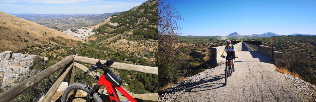
TransAndalus
A classic of cycle touring. A circular route of more than 2000km that runs through Andalusia. It is a route designed by and for cyclists, with a route mostly along dirt tracks, paths and cattle trails, avoiding busy roads and where mountain bikes are the most common sight.
As it is a self-guided route with no specific signposting, it is essential to carry a GPS with the tracks and to plan each stage.
The TransAndalus is a very demanding but incredibly rewarding route for those looking to discover Andalusia in a different way, and with lots of nature.
Stages and difficulties
As I said, by cyclists for cyclists, with routes that are not excessively long but with some good climbs. And although the 23-stage version of the official website (www.transandalus.org) is well known, once again the friends of conAlforjas.com propose a somewhat more affordable option in 39 stages.
- Tarifa – Algeciras (56km/+1.343m)
- Algeciras – Jimena de la Frontera (67km/+901m)
- Jimena de la Frontera – El Colmenar (40km/+1.206m)
- El Colmenar – Ronda (56km/+1.895m)
- Ronda – Ardales (48km/+1.160m)
- Ardales – Antequera (50km/+1.980m)
- Antequera – Ventas de Zafarraya (66km/+1.576m)
- Ventas de Zafarraya – Jayena (53km/+1.204m)
- Jayena – Lanjarón (65km/+1.942m)
- Lanjarón – Capileira (40km/+1.914m)
- Capileira – Cádiar (42km/+1.168m)
- Cádiar – Laroles (30km/+1.164m)
- Laroles – Instinción (74km/+1.767m)
- Instinción – Almería (68km/+1.820m)
- Almería – San José (45km/+398m)
- San José – Agua Amarga (45km/+678m)
- Agua Amarga – Uleila del Campo (65km/+1.477m)
- Uleila del Campo – Bacares (44km/+1.675m)
- Bacares – Baza (55km/+743m)
- Baza – Embalse de la Bolera (43km/+713m)
- Embalse de la Bolera – Pontones (62km/+1.453m)
- Pontones – Beas de Segura (71km/+1.821m)
- Beas de Segura – Aldeaquemada (78km/+1.497m)
- Aldeaquemada – Baños de la Encina (79km/+1.245m)
- Baños de la Encina – Marmolejo (53km/+704m)
- Marmolejo – Villanueva de Córdoba (73km/+1.343m)
- Villanueva de Córdoba – Hinojosa del Duque (69km/+743m)
- Hinojosa del Duque – Fuente Ovejuna (43km/+457m)
- Fuente Ovejuna – Alanís (60km/+1.278m)
- Alanís – Almadén de la Plata (76km/+1.355m)
- Almadén de la Plata – Aracena (57km/+1.089m)
- Aracena – Aroche (50km/+988m)
- Aroche – Valverde del Camino (84km/+1.462m)
- Valverde del Camino – Moguer (43km/+165m)
- Moguer – Matalascañas (50km/+137m)
- Matalascañas – Sanlucar de Barrameda (29km/+5m) (check tides)
- Sanlucar de Barrameda – Chiclana (75km/+297m)
- Chiclana – Barbate (53km/+394m)
- Barbate – Tarifa (45km/+518m)
Best time of the year to do the TransAndalus
The weather should be taken into account, as summer temperatures can be extreme in some regions. Early spring and late autumn would be the best times in terms of temperature, or take advantage of the mornings if you are closer to the summer months.
What to take on a cycling trip to 4 basics
- Carrying panniers and distributing their weight well. It may not seem to make much difference, but after a few kilometres, you will really notice if the weight is well distributed.
- Plan the route to suit your level and identify possible accommodation/camping sites. For the latter option, check the camping laws in each area to avoid surprises.
- Every gram counts. If you are going to make more trips like this one, consider investing in higher quality accessories and less weight (think about a tent if you do not sleep in hotels, sleeping bag, cooker, ...).
- Safety first and foremost. Depending on the route, you will have to ride on many stretches of road, so the more visible you are to other road users, the better. Think about lights and reflectors for the evening/night, but also flashy clothes during the day, so that you can be seen from far away.
Marketing, Web & Design
After studying in my hometown of Barcelona and spending several years abroad, I relocated in 2018 to Cabrales, a beautiful rural area in Northern Spain. I invite you to check out some photos of Cabrales to see the incredible views we enjoy from our office!
After a few years in reservations, I now manage the website and marketing for S-Cape Travel, where I handle design tasks, blog writing, and attend specialized travel fairs.


Opening hours: Mon-Fri 9:00am – 6:00pm (CET)
Opening hours: Mon-Fri 9:00am – 6:00pm (CET)