


How difficult Is the Camino de Santiago? Distance & how long does it take to walk it?
Is the Camino de Santiago difficult? It depends. And it is not easy to answer, since you have to assess your physical condition, what Camino or what stages you want to do, and how many days in a row you plan to walk.
As we already know, there are several routes to Santiago and each one has its own particular characteristics. You can start, for example, with the Portuguese Way along the coast, the easiest and practically flat route. Or dare with the Primitive Way or the first stages of the Northern Way, where the ascents and descents will test your legs.
In this article you will find the details you need to know which Camino is for you.
The Camino in 1 week
.png)
French Way from Sarria, the last 100 km (62 miles)
Moderate
Although it is not the easiest part of the Camino, the 5-6 stages that separate Sarria and Santiago are the most popular because they allow you to obtain the Compostela. This final stretch of the Camino Francés gathers the highest number of pilgrims since, apart from being the busiest route, other paths converge in Arzúa. They are relatively long stages, one of up to 29 km (18 miles), but you can divide them in 2 if they are too many kilometres in one day. The most demanding part is at the beginning, two stages of 22-25 km (14-16 miles) and ascents between 350 and 500 m.
- Length: 114 km (71 miles) from Sarria to Santiago de Compostela
- Average days needed: 5 days
- Distance per day: 18 - 25 km (11 - 16 miles)
- Elevation profile:
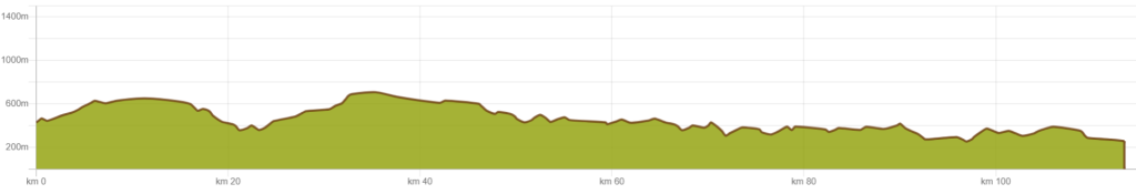
- From Sarria to Portomarín 22 km (14 miles), 7 hrs, 375 m ascent, 400 m descent
- From Portomarín to Palas de Rei 25 km (16 miles), 7,5 - 8 hrs, 500 m ascent, 290 m descent
- From Palas de Rei to Arzúa 29 km (18 miles), 7,5 - 8 hrs, 250 m ascent, 400 m descent
- From Arzúa to O Pino 18 km (11 miles), 5 hrs, 200 m ascent, 225 m descent
- From O Pino to Santiago de Compostela 21 km (13 miles), 5 hrs, 350 m ascent, 370 m descent
%20-%202024-10-29T162320-890.png)
Portuguese Way from Tui, the last 100km (62 miles)
Easy-medium
The last section of the Camino Portuguese, which runs through Galicia, has slightly higher ascents and descents than the previous sections, from 350 to 600 in the last stage, but it is still one of the easiest options to get to Santiago.
- Length: 114km (71 miles) from Tui to Santiago de Compostela
- Average days needed: 6 days
- Distance per day: Between 15 and 24 km (9 - 15 miles)
- Elevation profile:
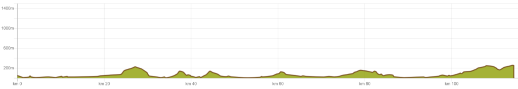
- From Tui to O Porriño (17 km / 10.5 mi)
- From O Porriño to Redondela (15 km / 9.3 mi)
- From Redondela to Pontevedra (20 km / 12.4 mi)
- From Pontevedra to Caldas de Reis (21 km / 13 mi)
- From Caldas de Reis to Padrón (19 km / 11.8 mi)
- From Padrón to Santiago (25 km / 15.5 mi)
.png)
Camino Lebaniego
Easy
Although the first two stages of the Camino Lebaniego are a bit tedious because they reach 30km (19 miles) per day and because you have to walk along stretches of road, you only need 3 or 4 days to complete it. You also have the option of doing it in 5 stages, but bear in mind that there is not much accommodation in the area, so we recommend planning ahead.
- Length: approximately 72 km (45 miles) from San Vicente de la Barquera to Santo Toribio de Liébana.
- Average days needed: 3-4 days
- Distance per day: Two stages of 30km and one of 15km (19 and 9 miles). The first two stages can be converted into 3
- Elevation profile:

- From San Vicente de la Barquera to Cades (28 km / 17.4 mi )
- From Cades to Cabañes (31 km / 19 mi)
- From Cabañes to Santo Toribio (14 km / 8.7 mi)
.png)
Camino Sanabrés, the last 100km (62 miles)
Moderate
As you can see in the elevation profile below, more than half of the route of the Camino Sanabrés is uphill. There are a couple of days that are a bit more demanding because of the constant and steeper ascents or descents, but the rest is gentle.
- Length: 105 km (65 miles) from Ourense to Santiago de Compostela.
- Average days needed: 4-5 days
- Distance per day: Between 21 and 35 km (13 and 22 miles), being possible to divide the longest stage in two.
- Elevation profile:

- From Ourense to Cea (22.5 km /14 mi)
- From Cea to A Gouxa (15 - 19 km / 9,5 - 12 mi)
- From Santo Domingo to A Ponte Taboada (20.5 km / 13 mi)
- From Silleda to Vedra (24 - 22 km / 15 - 13,5 mi)
- From Vedra to Santiago de Compostela (19.5 km / 12 mi)
.png)
The Camino Inglés
Moderate
The English Way is considered of moderate difficulty due to some unevenness and routes of up to 24km (15 miles), but a short total length. In general, it remains fairly flat, gradually rising from sea level to 400m and then descending a little again until reaching Santiago.
- Length: 119km (74 miles) from Ferrol to Santiago de Compostela
- Average days needed: 6 days
- Distance per day: Between 15 and 24 km (9 and 15 miles)
- Elevation profile:

- From Ferrol to Neda (15,3 km / 9.5 mi)
- From Neda to Pontedeume ( 12,2 km / 7.6 mi)
- From Pontedeume to Betanzos (19,7 km / 12 mi)
- From Betanzos to Hospital de Bruma (24,2 km / 15 mi)
- From Hospital de Bruma to Sigüeiro (24,4 km / 15.2 mi)
- From Sigüeiro to Santiago de Compostela (15,7 km / 9.8 mi)
The Camino in 2 weeks
.png)
Camino Portuguese from Porto
Easy
The Portuguese Way is known as the easiest as it has practically no gradients. However, there are stages of up to 27 km (17 miles) and the exception of Barcelos - Ponte da Lima, which is almost 35 km (22 miles) long and can be divided into two days.
- Length: 260 km (153 miles) from Oporto to Santiago de Compostela
- Average days needed: 11-12 days
- Distance per day: Between 15 and 28 km (11 and 17 miles)
- Elevation profile:

- From Porto to Vilarinho (27 km / 16.8 miles, 320 m ascent / 250 m descent)
- From Vilarinho to Barcelos (27 km / 16.8 miles, 300 m ascent / 320 m descent)
- From Barcelos to Ponte de Lima (34 km / 21.1 miles, 420 m ascent / 430 m descent)
- From Ponte de Lima to Rubiães (18 km / 11.2 miles, 500 m ascent / 250 m descent)
- From Rubiães to Tui (19 km / 11.8 miles, 240 m ascent / 470 m descent)
- From Tui to O Porriño (18 km / 11.2 miles, 150 m ascent / 140 m descent)
- From O Porriño to Redondela (16 km / 9.9 miles, 250 m ascent / 230 m descent)
- From Redondela to Pontevedra (19 km / 11.8 miles, 280 m ascent / 280 m descent)
- From Pontevedra to Caldas de Reis (23 km / 14.3 miles, 180 m ascent / 160 m descent)
- From Caldas de Reis to Padrón (19 km / 11.8 miles, 150 m ascent / 160 m descent)
- From Padrón to Santiago de Compostela (24 km / 14.9 miles, 330 m ascent / 120 m descent)
.png)
Camino Sanabrés
Moderate
The Sanabrés Way is a variant of the Silver Route which, from the village of Granja de Moreruela, in Zamora, continues northwestwards, entering Santiago via Ourense. It is once in Galicia that it becomes more demanding with ascents of up to 700m.
- Length: 370 km (230 miles) from Granja de Moreruela to Santiago de Compostela.
- Average days needed: 13-14 days
- Distance per day: 22 and 33 km (14 and 21 miles)
- Elevation profile:

- From Granja de Moreruela to Tábara (25 km / 15.5 miles, 200 m ascent / 160 m descent)
- From Tábara to Santa Marta de Tera (23 km / 14.3 miles, 170 m ascent / 190 m descent)
- From Santa Marta de Tera to Rionegro del Puente (20 km / 12.4 miles, 150 m ascent / 140 m descent)
- From Rionegro del Puente to Puebla de Sanabria (33 km / 20.5 miles, 380 m ascent / 290 m descent)
- From Puebla de Sanabria to Lubián (31 km / 19.3 miles, 730 m ascent / 440 m descent)
- From Lubián to A Gudiña (25 km / 15.5 miles, 740 m ascent / 820 m descent)
- From A Gudiña to Laza (34 km / 21.1 miles, 550 m ascent / 1,050 m descent)
- From Laza to Xunqueira de Ambía (32 km / 19.9 miles, 670 m ascent / 750 m descent)
- From Xunqueira de Ambía to Ourense (22 km / 13.7 miles, 280 m ascent / 450 m descent)
- From Ourense to Cea (22 km / 13.7 miles, 640 m ascent / 250 m descent)
- From Cea to Castro Dozón (16 km / 9.9 miles, 420 m ascent / 260 m descent)
- From Castro Dozón to Silleda (28 km / 17.4 miles, 420 m ascent / 640 m descent)
- From Silleda to Ponte Ulla (20 km / 12.4 miles, 300 m ascent / 450 m descent)
- From Ponte Ulla to Santiago de Compostela (21 km / 13 miles, 370 m ascent / 270 m descent)
.png)
The Camino Primitivo
Moderate, with some demanding stages.
The Camino Primitivo, together with the first part of the Northern Way, is considered one of the most demanding of the Caminos. For those looking for a challenge, you can start the Camino del Norte from Irún to Oviedo and then take the Primitive route to Santiago.
The most difficult part of the Primitivo is before reaching Galicia, where you have to overcome a couple of mountain passes, such as the Puerto del Palo, but the views are the reward. In the elevation profile below, you can clearly see the two mountain passes, and how, once in Galicia, the gradient becomes much gentler.
- Length: 310 km (192 miles) from Oviedo to Santiago de Compostela.
- Average days needed: 15 days
- Distance per day: between 15 and 25 km (10 and 15 miles)
- Elevation profile:

- From Oviedo to Grado (26 km / 16 mi, 250 m ascent, 375 m descent)
- From Grado to Salas (22.5 km / 14 mi, 425 m ascent, 350 m descent)
- From Salas to Tineo (20 km / 12,5 mi, 575 m ascent, 300 m descent)
- From Tineo to Campiello (14 km / 8,5 mi, 300 m ascent, 340 m descent)
- From Borres to Berducedo (18 km - 22 km / 11 - 13,5 mi, 620 m ascent and 450 m descent)
- From Berducedo to Grandas de Salime (15 km / 9,5 mi, 330 m ascent, 970 m descent)
- From Grandas de Salime to Fonsagrada (20-25 km / 12,5-15,5 mi, 530 m ascent, 175 / 225 m descent)
- From Fonsagrada to Paradavella (15 km/ 9,5 mi, 400 m ascent, 650 m descent)
- From Paradavella to Castroverde (20 km / 12,5 mi, 400 m ascent, 475 descent)
- From Castroverde to Lugo (22 km / 13,5 mi, 150 m ascent, 250 m descent)
- From Lugo to Ferreira (26.5 km / 16,5 mi, 200 m ascent and descent)
- From Ferreira to Melide (20 km / 12,5 mi, 280 m ascent, 350 m descent)
- From Melide to Arzúa (14 km / 8,5 mi, 150 m ascent, 200 m descent)
- From Arzúa to A Rua (18 km / 11 mi, 150 m ascent, 200 m descent)
- From A Rua to Santiago de Compostela (21 km / 13 mi, 350 m ascent and descent)
The Camino in 3-4 weeks
.png)
Camino Portuguese from Lisbon
Easy
The Portuguese Way to Santiago is known for its low difficulty. The most demanding stages have climbs of up to 250m and, although some stages can be as long as 30 km (19 miles), you always have the option of doing it in two days. When you get to Galicia there are some steeper climbs, but nothing too steep.
- Length: 620 km (385 miles) from Lisbon to Santiago de Compostela.
- Average days needed: 24-27 days
- Distance per day: between 18 and 30 km (11 and 19 miles)
- Elevation profile:

- From Lisbon to Alverca do Ribatejo (25 km / 15.5 miles, 130 m ascent / 100 m descent)
- From Alverca do Ribatejo to Azambuja (31 km / 19.3 miles, 120 m ascent / 110 m descent)
- From Azambuja to Santarém (32 km / 19.9 miles, 250 m ascent / 50 m descent)
- From Santarém to Golegã (31 km / 19.3 miles, 150 m ascent / 200 m descent)
- From Golegã to Tomar (30 km / 18.6 miles, 300 m ascent / 200 m descent)
- From Tomar to Alvaiázere (32 km / 19.9 miles, 500 m ascent / 400 m descent)
- From Alvaiázere to Ansiao (12 km / 7.5 miles, 250 m ascent / 200 m descent)
- From Ansiao to Rabaçal (20 km / 12.4 miles, 300 m ascent / 350 m descent)
- From Rabaçal to Coimbra (28 km / 17.4 miles, 350 m ascent / 450 m descent)
- From Coimbra to Mealhada (23 km / 14.3 miles, 200 m ascent / 250 m descent)
- From Mealhada to Águeda (26 km / 16.2 miles, 250 m ascent / 280 m descent)
- From Águeda to Albergaria-a-Velha (15 km / 9.3 miles, 200 m ascent / 180 m descent)
- From Albergaria-a-Velha to Oliveira de Azeméis (19 km / 11.8 miles, 280 m ascent / 220 m descent)
- From Oliveira de Azeméis to Grijó (32 km / 19.9 miles, 300 m ascent / 350 m descent)
- From Grijó to Porto (22 km / 13.7 miles, 200 m ascent / 250 m descent)
- From Porto to Vilarinho (27 km / 16.8 miles, 320 m ascent / 250 m descent)
- From Vilarinho to Barcelos (27 km / 16.8 miles, 300 m ascent / 320 m descent)
- From Barcelos to Ponte de Lima (34 km / 21.1 miles, 420 m ascent / 430 m descent)
- From Ponte de Lima to Rubiães (18 km / 11.2 miles, 500 m ascent / 250 m descent)
- From Rubiães to Tui (19 km / 11.8 miles, 240 m ascent / 470 m descent)
- From Tui to O Porriño (18 km / 11.2 miles, 150 m ascent / 140 m descent)
- From O Porriño to Redondela (16 km / 9.9 miles, 250 m ascent / 230 m descent)
- From Redondela to Pontevedra (19 km / 11.8 miles, 280 m ascent / 280 m descent)
- From Pontevedra to Caldas de Reis (23 km / 14.3 miles, 180 m ascent / 160 m descent)
- From Caldas de Reis to Padrón (19 km / 11.8 miles, 150 m ascent / 160 m descent)
- From Padrón to Santiago de Compostela (24 km / 14.9 miles, 330 m ascent / 120 m descent)
The Camino in more than 4 weeks
.png)
The complete Camino Francés
Easy, with moderate stages.
The average gradient of the French Way is generally around 260m ascent and descent, with more demanding stages such as the O Cebreiro section, with up to 660m of ascent. What raises the level of difficulty of this route is the number of days you want to walk in a row.
Many pilgrims start the French Way in Saint-jean-Pied-de-Port, and that stage to Roncesvalles, about 25km (16 miles), is tough: 1,200m positive and 500m negative, but with beautiful views.
- Length: About 770 km (478 miles) from Roncesvalles (border between Spain and France) to Santiago de Compostela
- Average days needed: 30 - 35 days
- Distance per day: Between 20 and 26 km (12 and 16 miles)
- Elevation profile:

- From Roncesvalles to Zubiri (22.3 km / 13.8 mi, 620 m ascent / 520 m descent)
- From Zubiri to Pamplona (20.2 km / 12.5 mi, 270 m ascent / 210 m descent)
- From Pamplona to Puente la Reina (24.7 km / 15.3 mi, 230 m ascent / 270 m descent)
- From Puente la Reina to Estella (21.4 km / 13.3 mi, 230 m ascent / 210 m descent)
- From Estella to Los Arcos (21.2 km / 13.2 mi, 250 m ascent / 300 m descent)
- From Los Arcos to Viana (21.3 km / 13.2 mi, 220 m ascent / 280 m descent)
- From Viana to Logroño (10 km / 6.2 mi, 80 m ascent / 120 m descent)
- From Logroño to Nájera (29.6 km / 18.4 mi, 350 m ascent / 450 m descent)
- From Nájera to Santo Domingo de la Calzada (21.3 km / 13.2 mi, 210 m ascent / 250 m descent)
- From Santo Domingo de la Calzada to Belorado (22.6 km / 14 mi, 320 m ascent / 380 m descent)
- From Belorado to San Juan de Ortega (24.3 km / 15.1 mi, 550 m ascent / 600 m descent)
- From San Juan de Ortega to Burgos (26.5 km / 16.5 mi, 250 m ascent / 150 m descent)
- From Burgos to Hornillos del Camino (20.4 km / 12.7 mi, 200 m ascent / 210 m descent)
- From Hornillos del Camino to Hontanas (20.6 km / 12.8 mi, 280 m ascent / 320 m descent)
- From Hontanas to Castrojeriz (21.2 km / 13.2 mi, 240 m ascent / 320 m descent)
- From Castrojeriz to Frómista (25.5 km / 15.8 mi, 290 m ascent / 330 m descent)
- From Frómista to Carrion de los Condes (19.4 km / 12.1 mi, 220 m ascent / 200 m descent)
- From Carrion de los Condes to Calzadilla de la Cueza (17.4 km / 10.8 mi, 180 m ascent / 160 m descent)
- From Calzadilla de la Cueza to Mansilla de las Mulas (24.7 km / 15.3 mi, 230 m ascent / 210 m descent)
- From Mansilla de las Mulas to León (18.7 km / 11.6 mi, 220 m ascent / 240 m descent)
- From León to San Martín del Camino (25.7 km / 16 mi, 300 m ascent / 270 m descent)
- From San Martín del Camino to Astorga (23.7 km / 14.7 mi, 240 m ascent / 220 m descent)
- From Astorga to Rabanal del Camino (20.3 km / 12.6 mi, 370 m ascent / 340 m descent)
- From Rabanal del Camino to Ponferrada (27.6 km / 17.2 mi, 380 m ascent / 440 m descent)
- From Ponferrada to Villafranca del Bierzo (24.5 km / 15.2 mi, 250 m ascent / 220 m descent)
- From Villafranca del Bierzo to O Cebreiro (28.5 km / 17.7 mi, 1,100 m ascent / 100 m descent)
- From O Cebreiro to Triacastela (21.3 km / 13.2 mi, 650 m ascent / 200 m descent)
- From Triacastela to Sarria (18.4 km / 11.4 mi, 290 m ascent / 370 m descent)
- From Sarria to Portomarín (22.6 km / 14 mi, 290 m ascent / 340 m descent)
- From Portomarín to Palas de Rei (24.2 km / 15 mi, 330 m ascent / 360 m descent)
- From Palas de Rei to Melide (15.6 km / 9.7 mi, 240 m ascent / 270 m descent)
- From Melide to Arzúa (14.8 km / 9.2 mi, 240 m ascent / 260 m descent)
- From Arzúa to A Rúa (18.8 km / 11.7 mi, 250 m ascent / 300 m descent)
- From A Rúa to Santiago de Compostela (21 km / 13 mi, 340 m ascent / 380 m descent)
.png)
Camino del Norte
Moderate
The Camino del Norte is one of the hardest routes due to its mountainous profile and continuous slopes, especially in the Basque Country and Asturias, where some stages can accumulate more than 1,000 m of positive height gain. Rainy or windy days can also affect the difficulty.
- Length: 825 km (513 miles) from Irún to Santiago de Compostela.
- Average days needed: 34-37 days
- Distance per day: Between 18 and 30 km (11 and 19 miles), with a couple of stages of almost 40 km (25 miles) that can be split up.
- Elevation profile:

From Irún to Hondarribia (6.5 km / 4.0 mi, 150 m ascent)
From Hondarribia to San Sebastián (24.5 km / 15.2 mi, 350 m ascent)
From San Sebastián to Zarautz (22 km / 13.7 mi, 550 m ascent)
From Zarautz to Getaria (8.5 km / 5.3 mi, 250 m ascent)
From Getaria to Deba (21 km / 13.0 mi, 300 m ascent)
From Deba to Markina-Xemein (22.5 km / 14.0 mi, 500 m ascent)
From Markina-Xemein to Gernika (23 km / 14.3 mi, 400 m ascent)
From Gernika to Bilbao (31 km / 19.3 mi, 765 m ascent)
From Bilbao to Portugalete (13 km / 8.1 mi, 150 m ascent)
From Portugalete to Castro Urdiales (27 km / 16.8 mi, 529 m ascent)
From Castro Urdiales to Laredo (26 km / 16.2 mi, 455 m ascent)
From Laredo to Güemes (26 km / 16.2 mi, 288 m ascent)
From Güemes to Santander (20 km / 12.4 mi, 188 m ascent)
From Santander to Santillana del Mar (26 km / 16.2 mi, 400 m ascent)
From Santillana del Mar to Comillas (22 km / 13.7 mi, 460 m ascent)
From Comillas to Colombres (28 km / 17.4 mi, 460 m ascent)
From Colombres to Llanes (23 km / 14.3 mi, 320 m ascent)
From Llanes to Ribadesella (32 km / 19.9 mi, 330 m ascent)
From Ribadesella to Colunga (20 km / 12.4 mi, 340 m ascent)
From Colunga to Villaviciosa (18 km / 11.2 mi, 310 m ascent)
From Villaviciosa to Pola de Siero (26 km / 16.2 mi, 530 m ascent)
From Pola de Siero to Oviedo (17 km / 10.6 mi, 190 m ascent)
From Oviedo to Avilés (29 km / 18.0 mi, 370 m ascent)
From Avilés to Muros del Nalón (23 km / 14.3 mi, 560 m ascent)
From Muros del Nalón to Soto de Luiña (15 km / 9.3 mi, 430 m ascent)
From Soto de Luiña to Cadavedo (19 km / 11.8 mi, 580 m ascent)
From Cadavedo to Luarca (15 km / 9.3 mi, 220 m ascent)
From Luarca to Navia (20 km / 12.4 mi, 360 m ascent)
From Navia to Tapia de Casariego (21 km / 13.0 mi, 280 m ascent)
From Tapia de Casariego to Ribadeo (12 km / 7.5 mi, 110 m ascent)
From Ribadeo to Gondán (21 km / 13.0 mi, 600 m ascent)
From Gondán to Mondoñedo (16 km / 9.9 mi, 450 m ascent)
From Mondoñedo to Abadín (17 km / 10.6 mi, 630 m ascent)
From Abadín to Vilalba (21 km / 13.0 mi, 250 m ascent)
From Vilalba to Baamonde (19 km / 11.8 mi, 210 m ascent)
From Baamonde to Alto Mamoa (20 km / 12.4 mi, 400 m ascent)
From Alto Mamoa to Sobrado dos Monxes (24 km / 14.9 mi, 400 m ascent)
From Sobrado dos Monxes to Arzúa (22 km / 13.7 mi, 220 m ascent)
From Arzúa to A Rúa (18 km / 11.2 mi, 200 m ascent)
From A Rúa to Santiago de Compostela (21 km / 13.0 mi, 350 m ascent)
.png)
Le Puy Camino, the Via Podiensis in France
Moderate, with demanding sections.
Although no stage stands out for being overly long, there are few sections with no gradient, especially in the Aubrac area and towards the end, as we approach the Pyrenees.
It should be borne in mind that in the Aubrac area there are few services, although the route is always well signposted, which makes it easier to prepare beforehand.
The Via Podiensis ends in Saint-Jean-Pied-de-Port, from where you can continue to Roncesvalles along the French Way, or join the Northern Way from Irún.
- Length: About 740 km (460 miles) from Le Puy-en-Velay to Saint-Jean-Pied-de-Port.
- Average days needed: 34-39 days
- Distance per day: Between 20 and 30 km (12 and 19 miles)
- Elevation profile:

- From Le Puy-en-Velay to St Privat D’Allier (23.5 km / 14.6 mi, 573 m ascent)
- From St Privat D’Allier to Saugues (19 km / 11.8 mi, 694 m ascent)
- From Saugues to Les Faux (28 km / 17.4 mi, 620 m ascent)
- From Les Faux to Aumont-Aubrac (22 km / 13.7 mi, 383 m ascent)
- From Aumont-Aubrac to Nasbinals (26 km / 16.2 mi, 392 m ascent)
- From Nasbinals to Saint-Chély d’Aubrac (16 km / 9.9 mi, 207 m ascent)
- From Saint-Chély d’Aubrac to St Côme d'Olt (17 km / 10.6 mi, 248 m ascent)
- From St Côme d'Olt to Estaing (20 km / 12.4 mi, 500 m ascent)
- From Estaing to Golinhac (14 km / 8.7 mi, 512 m ascent)
- From Golinhac to Conques (14 km / 8.7 mi, 512 m ascent)
- From Conques to Livinhac-le-Haut (24 km / 14.9 mi, 671 m ascent)
- From Livinhac-le-Haut to Figeac (24 km / 14.9 mi, 500 m ascent)
- From Figeac to Gréalou (24.5 km / 15.2 mi, 412 m ascent)
- From Gréalou to Cajarc (11 km / 6.8 mi, 109 m ascent)
- From Cajarc to Limogne-en-Quercy (22 km / 13.7 mi, 230 m ascent)
- From Limogne-en-Quercy to Lalbenque (22 km / 13.7 mi, 230 m ascent)
- From Lalbenque to Cahors (18 km / 11.2 mi, 170 m ascent)
- From Cahors to Lascabanes (23 km / 14.3 mi, 414 m ascent)
- From Lascabanes to Lauzerte (25 km / 15.5 mi, 616 m ascent)
- From Lauzerte to Moissac (28 km / 17.4 mi, 469 m ascent)
- From Moissac to Auvillar (22 km / 13.7 mi, 334 m ascent)
- From Auvillar to Flamarens (14 km / 8.7 mi, 364 m ascent)
- From Flamarens to Lectoure (19 km / 11.8 mi, 274 m ascent)
- From Lectoure to La Romieu (18.5 km / 11.5 mi, 300 m ascent)
- From La Romieu to Condom (13 km / 8.1 mi, 217 m ascent)
- From Condom to Montréal-du-Gers (17 km / 10.6 mi, 238 m ascent)
- From Montréal-du-Gers to Eauze (17 km / 10.6 mi, 198 m ascent)
- From Eauze to Nogaro (20.5 km / 12.7 mi, 269 m ascent)
- From Nogaro to Barcelonne-du-Gers (25 km / 15.5 mi, 207 m ascent)
- From Barcelonne-du-Gers to Miramont-Sensacq (20 km / 12.4 mi, 416 m ascent)
- From Miramont-Sensacq to Fichous-Riumayou (26 km / 16.2 mi, 481 m ascent)
- From Fichous-Riumayou to Arthez-de-Béarn (19 km / 11.8 mi, 155 m ascent)
- From Arthez-de-Béarn to Sauvelade (20.5 km / 12.7 mi, 361 m ascent)
- From Sauvelade to Aroue (30 km / 18.6 mi, 431 m ascent)
- From Aroue to Saint-Palais (26 km / 16.2 mi, 370 m ascent)
- From Saint-Palais to Ostabat-Asme (10.5 km / 6.5 mi, 390 m ascent)
- From Ostabat-Asme to Saint-Jean-Pied-de-Port (22.5 km / 14.0 mi, 397 m ascent)
.png)
Via de la Plata
Moderate, mainly due to the length of the route and the long stages.
The stages of the Via de la Plata are relatively flat, with a couple of rougher areas in the Sierra de Aracena and the pass to Galicia. Apart from the length of this route, almost 1000 km (621 miles) in total, you have to take into account the heat and the stages with little shade, especially in the summer months. If you are lucky enough to be able to complete it in one go, the best time would be to start in spring to reach the north of the peninsula by summer.
- Length: 964 km (599 miles) from Seville to Santiago de Compostela
- Average days needed: 36-39 days
- Distance per day: Between 20-25 km (12 - 16 miles)
- Elevation profile:

- From Seville to Guillena (23 km / 14.2 mi, 158 m ascent / 124 m descent)
- From Guillena to Castilblanco de los Arroyos (18 km / 11 mi, 386 m ascent / 91 m descent)
- From Castilblanco to Almadén de la Plata (28.7 km / 17.8 mi, 649 m ascent / 521 m descent)
- From Almadén de la Plata to Monesterio (35 km / 21.7 mi, 850 m ascent / 575 m descent)
- From Monesterio to Fuente de Cantos (20.6 km / 12.8 mi, 291 m ascent / 432 m descent)
- From Fuente de Cantos to Zafra (24.7 km / 15.3 mi, 212 m ascent / 288 m descent)
- From Zafra to Villafranca de los Barros (20.5 km / 12.7 mi, 246 m ascent / 339 m descent)
- From Villafranca to Torremejía (27.5 km / 17 mi, 105 m ascent / 221 m descent)
- From Torremejía to Mérida (15.6 km / 9.6 mi, 79 m ascent / 175 m descent)
- From Mérida to Aljucén (17.4 km / 10.8 mi, 100 m ascent / 90 m descent)
- From Aljucén to Alcuéscar (20.4 km / 12.7 mi, 250 m ascent / 230 m descent)
- From Alcuéscar to Cáceres (37.4 km / 23.2 mi, 400 m ascent / 450 m descent)
- From Cáceres to Embalse de Alcántara (33.6 km / 20.9 mi, 350 m ascent / 300 m descent)
- From Embalse de Alcántara to Grimaldo (20.1 km / 12.5 mi, 250 m ascent / 200 m descent)
- From Carcaboso to Aldeanueva del Camino (38.7 km / 24 mi, 420 m ascent / 380 m descent)
- From Aldeanueva del Camino to La Calzada de Béjar (23.8 km / 14.8 mi, 520 m ascent / 330 m descent)
- From La Calzada de Béjar to Fuenterroble de Salvatierra (20.7 km / 12.9 mi, 310 m ascent / 260 m descent)
- From Fuenterroble to San Pedro de Rozados (27.3 km / 17 mi, 420 m ascent / 340 m descent)
- From San Pedro de Rozados to Salamanca (24.4 km / 15.2 mi, 140 m ascent / 280 m descent)
- From Salamanca to El Cubo de la Tierra del Vino (36.5 km / 22.7 mi, 270 m ascent / 260 m descent)
- From El Cubo to Zamora (33.2 km / 20.6 mi, 220 m ascent / 230 m descent)
- From Zamora to Montamarta (19.4 km / 12 mi, 150 m ascent / 90 m descent)
- From Montamarta to Granja de Moreruela (25.8 km / 16 mi, 200 m ascent / 230 m descent) Here the route splits. This list follows the Sanabria route, which merges with the Camino Sanabrés.
- From Granja to Tábara (23.1 km / 14.3 mi, 360 m ascent / 280 m descent)
- From Tábara to Santa Marta de Tera (26.3 km / 16.3 mi, 300 m ascent / 350 m descent)
- From Santa Marta to Rionegro del Puente (26.1 km / 16.2 mi, 390 m ascent / 270 m descent)
- From Rionegro to Puebla de Sanabria (33.2 km / 20.6 mi, 540 m ascent / 470 m descent)
- From Puebla to Lubián (28.4 km / 17.6 mi, 700 m ascent / 520 m descent)
- From Lubián to A Gudiña (24.2 km / 15 mi, 590 m ascent / 610 m descent)
- From A Gudiña to Laza (34.3 km / 21.3 mi, 540 m ascent / 880 m descent)
- From Laza to Xunqueira de Ambía (33.5 km / 20.8 mi, 780 m ascent / 640 m descent)
- From Xunqueira to Ourense (22.4 km / 13.9 mi, 300 m ascent / 410 m descent)
- From Ourense to Cea (22.5 km / 14 mi, 660 m ascent / 230 m descent)
- From Cea to Dozón (16.7 km / 10.4 mi, 510 m ascent / 140 m descent)
- From Dozón to A Laxe (16.8 km / 10.4 mi, 190 m ascent / 380 m descent)
- From A Laxe to Outeiro (33.3 km / 20.7 mi, 430 m ascent / 510 m descent)
- From Outeiro to Santiago de Compostela (18.7 km / 11.6 mi, 310 m ascent / 290 m descent)
Considerations when choosing a Camino de Santiago
Each route has its own charm and level of difficulty. The distances and gradients vary between stages of the same route as it crosses different areas, each with its own orography and climatology. But apart from this, you have to take into account your physical condition. It is essential to prepare adequately for the Camino, considering both the number of days and the difficulty of each route.
Use these other guides to help you plan your next Camino.
- Guide to prepare your backpack for the Camino de Santiago
- What it is and how to get the Compostela
- Where to get and how to use the pilgrim's credential


Opening hours: Mon-Fri 9:00am – 6:00pm (CET)
Opening hours: Mon-Fri 9:00am – 6:00pm (CET)